I showed off some of the material from my original D&D game back in April. While I had hoped to revive a D&D game this year, I ended up involved in a D&D 5th Edition game with a set of HAWKs players instead. Nevertheless, I am still working toward actually doing this.
So, I took a few potential hobby projects with me, to fill any potential down-time during the family Christmas get-together. Happily, there wasn’t a lot of that, but what time I did have I spent on drawing the Myzantine Empire map.
Since I was on a roll, I decided I would pull something off my D&D to-do list, and draw a more decorative map of the region in which the adventurers will be based.
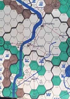
My original maps were drawn on SPI hex paper in the late 1970s, before I had done much reading in medieval demographics and agricultural history to get some sort of “realistic” grounding. I ended up a little skewed (perhaps not inappropriate for a map which probably doesn’t owe much to surveyors), but attemtped to translate approximately the section above into a more fantasy style:
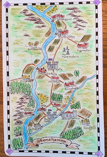

It does have a rather classic 20C fantasy novel look and feel to it.
ReplyDeleteOr even earlier; check out this very generic medieval-oid map from William Morris’s 1897 fantasy novel, The Sundering Flood: https://en.wikipedia.org/wiki/The_Sundering_Flood#/media/File:Sundering_Flood.jpg
ReplyDeleteWell, yup. Come to think of it, i think I've seen some early historical fiction with similar maps, possibly not quite so charming. I should follow that up.
ReplyDelete